Wellness
Phoenix’s Top Walking Trails Ranked by Distance and Difficulty
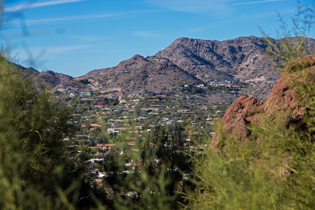
From the shady paths of Papago to the challenging climbs of Piestewa, here’s how Phoenix’s best walking trails measure up for every fitness level.
4 min read
Updated 1 h ago
Wellness
From the shady paths of Papago to the challenging climbs of Piestewa, here’s how Phoenix’s best walking trails measure up for every fitness level.
4 min read
Updated 1 h ago
Hikers and walkers across Phoenix are lacing up earlier than ever this July, with soaring temperatures pushing trail use to historic highs and making route selection a question of both stamina and safety. The city’s outdoor fitness community—already one of the most active in the Southwest—now counts more than a dozen key walking trails, each with its own sweet spot for distance, difficulty, and summer survival.
Phoenix just logged its hottest June on record, topping out at multiple daily highs over 110F. For fitness enthusiasts determined to keep their steps up and stress down, the right trail and timing matter more than ever. Fitness clubs like the Downtown Phoenix FitWalkers and the City of Phoenix’s "WalkPHX" program have reported bigger early-morning groups, and city rangers have posted extra warnings at popular trailheads about hydrating, beating midday heat, and knowing your limits. This surge tracks with a city Health & Wellness Office estimate that regular walking at safe times is up by 14% over last July, reflecting anxieties about indoor air quality and the enduring popularity of outdoor cardio.
Papago Park’s Double Butte Loop stands out as Phoenix’s friendliest urban hiking spot. The 2.2-mile loop, starting at the Galvin Parkway entrance near the Desert Botanical Garden, offers an almost-flat grade—a rare find so close to the city core. It’s fully exposed to the sun, but early risers (before 8 a.m.) get iconic red rock views and frequent breezes. For anyone looking to log casual steps with a stroller, dog, or low aerobic intensity, this path is as beginner-friendly as they come.
Moving up in challenge, the Dreamy Draw Recreation Area kicks off the start of a more moderate circuit. The Perl Charles Memorial Trail, a 4.2-mile out-and-back, begins just east of the Piestewa Peak trailhead parking off Squaw Peak Drive. It’s rated moderate, combining rolling ascents (total 638 feet of elevation gain) and loose rock with occasional shade from mesquite and palo verde. This is a perennial favorite among mid-level walkers—often used by Phoenix FitClub’s Saturday 6 a.m. walking group, whose route leader told me trailhead parking typically fills by 7 a.m. on weekends.
At the tougher end, the Piestewa Peak Summit Trail is not for the faint of heart—or knees. Its 1.2-mile climb may sound short, but the 1,200-foot elevation gain makes it one of the Valley’s most challenging city hikes. Trail traffic, especially near the top, can be dense by 7 a.m., but for those craving a serious fitness test (think: high-stepping intervals), it’s unmatched. Wayfinding is simple, but expect uneven stone, narrow switchbacks, and panoramic city views. City rangers note that this trail sees more heat exhaustion incidents than any other—reminding users that water and hats are not optional here.
According to Maricopa County Parks’ 2025 annual report, Phoenix-area trails hosted more than 5.6 million walkers and hikers last year—up 8% from 2024. Papago Park alone averages 1,500 walkers a day in the summer, while Piestewa draws double that on peak weekends. Regional heat advisories are currently posted through July 11, and the city’s "Cool Paths" campaign (including temporary water stations at major trailheads) will continue through Labor Day.
There’s no cost to use city or county walking paths; parking is free at most lots, though Phoenix Parks & Recreation’s pay lots at high-traffic preserves (such as South Mountain’s Pima Canyon trailhead) remain $5 per vehicle. Trail maps, safety alerts and event calendars can be found via the city’s new ActivePHX mobile app, which saw more than 12,000 downloads in June alone.
If you’re planning to hit the trails this week, city health coordinators recommend walking before 9 a.m. or after sunset, carrying at least two litres of water per person, and letting someone know your route—especially on moderate and hard-rated paths. With early-morning start times, shaded detours, and smart pacing, even Phoenix’s toughest summer can’t keep the city’s walking scene down for long.
About this article
Published by The Daily Phoenix
Spread the word
Daily brief
Free, in your inbox before 7am. Weekdays.
The Daily Network — local news across Australia